FOREWARD: This particular location has stumped and fooled many whom have attempted to visit it, myself included when I first visited within yards of this spot. Hopefully, my website will be the first to place it's enigma to rest, particularly that the exact NW corner is not presently in the roadway and can be safely accessed if care is exercised. Some background and history is in order, yet I don't presently have enough information to make this a true reference work, therefore, I must disclaim that the accuracy of all facts herein are not assured. If you're after the quick information, skip down to the HOW TO FIND portion, then come back to read the history later on. It's best to enjoy the whole leg of chicken (minus the bones) instead of just the tasty skin! Just sayin'.. ERRATA: The road at the NM/TX state line, heading eastward is Rinker Road, NOT Ritter Road. My apologies for any confusion or inconvenience. If this article contains other obvious errors, please notify me through email or @windmechanic on Twitter or Parler. Furthermore, I've recorded a video on 8/11/19 to be posted on YouTube of both methods in locating the Corner that this website already instructs. It will be linked from this page, once I've edited it.
Many who travel US 56 between Clayton, NM and Boise City, OK have no idea that Texas nearly juts out onto the highway, unless they have a GPS unit and healthy sense of curiousity. Some maps erroneously place this specific point in the center of this highway. A few others have tried to find it and have their reports on the 'Net. Now you get to read it from someone who found it, with instructions on finding it yourself. It's not always easy though! There are times the grass is really high at the marker and having a set of garden grass clippers with a metal detector will prove the easiest method of locating this spot. As you'll see, New Mexico is not bound to mow far from the highway in that corner as most of it rightfully belongs to Texas. A GPS is the easiest method of locating Rinker Road, with good signage and straddling the state line. I'll always pull over fairly close to the small fence off the roadway, although there's not much traffic on Rinker. I'll also clue you in that it's westward from the OK/NM state line, although you can head southward on that road, visit the Tripoint OK/NM/TX as noted at the bottom of this webpage, then head west on Rinker under 3 miles and the NW Corner pulloff would be on your left (southwestward) as you approach US 56. I may well add more images here by request to help you visit that point, although I'll give technology the chance to prove itself here. Verizon cell service is O.K. in that area, as you're a few miles outside of Clayton, which has many services and gasoline. Their supermarket is the Ranch Market, open every day except certain holidays, and is on US 87 East, (300 S. First St) if you're heading to Dalhart. The other nearest community is Felt, a few miles NE with basically no services, but a nice picnic area in their park.
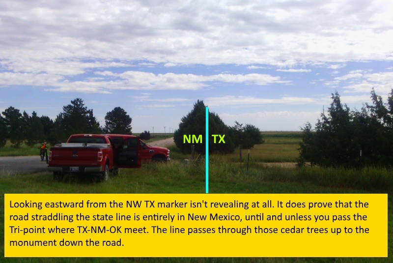
I first visited this general location in 2005 as part of the Guad Trip(tm), a 14 state, 2 week journey of 9500 miles from Arkansas, to Montana, then Arizona and back with CD, a long time friend who saw this trip as a game-changer for me. It was clearly an eye-opener as I got into a snowball fight in July with him atop Independence Pass, Colorado. I nearly landed a job in Wyoming (I was unemployed at the time) and we had already encountered some interesting characters along the way. After going through Clayton, NM heading east on US 56, we were primarily after the tri-point of TX-NM-OK which is due east of this location and was successfully found with no issues. Maps showed the NW TX marker existed, yet didn't give enough detail to state whether or not it was in the roadway. I stepped out to the middle of US 56 and had to accept this was the location, but further research told me otherwise. Fortunately, from my moving to this region in 2011, I've briefly revisited this site several times before finding the solution to this puzzle during September, 2015. Now the history lesson begins..
In the early days of Texas, her land claims went to the 42nd parallel and along the meridians between the sources of the Arkansas and Rio Grande Rivers, both in Colorado. From these river sources, a narrow chimney was formed which extended northward into modern-day Wyoming and essentially comprises Carbon County, where Rawlins and the State Pen are located. Earlier in the Guad Trip, CD and I visited Rawlins at a Taco Bell where the ice had run out and seagulls were busy in the hot mountain sunshine digging through what trash they could find. To imagine Texas being that large was a testament to their pioneers! Why did Texas willingly give up such holdings? It goes back to the Thirty-Six Thirty rule given in the Monroe Doctrine of 1820. This parallel was the boundary where slavery was prohibited north of it in the former Louisiana Purchase, except for Missouri (thus the Missouri Compromise). In 1850, Texas decided to maintain slavery and gave up all claims north of 36-30, yet received $10 Million to cover debts, and thus the Texas Compromise as areas westward claimed were relinquished. With this change, the state had to conduct a new survey for it's new buzzcut northern boundary. Completed during 1860 with a nicely straight line ending at this point (due to an earlier surveying error, taking away land from New Mexico Territory as it should have been at 103 degrees west) and began at 100 degrees west. Furthermore, the XIT Ranch's NW corner was at this exact point. The ranch was formed by a British investment group who funded the Capitol Building of Texas at Austin. As payment, well over 800,000 contiguous acres in 10 Texas Counties became the infamous XIT. Due to its massive size, certain operations were done in almost-entire counties. Dallam County, where the NW Corner is situated, handled much of the XIT steers. On the opposite side of this county, Dalhart is located in both Dallam and Hartley Counties, thus the combination name. Certainly, this is nothing unique in Texas as Amarillo is in both Potter and Randall Counties. I mention the XIT for another reason. The monument marker which once occupied this spot had been amended with "XIT" at some point. The XIT ranch split up and sold off after the company wanted their money.
So what happened here? US Highway 56 expanded and the Grant Monument, named after the surveyor who completed it, was too close to the highway thus causing a potential traffic hazard, and was removed and recessed in the ground for safety. This isn't unique by any means! Less than 100 air miles away is the tri-point of CO-KS-OK about 8 miles west of Elkhart, KS. The monument is below the dirt road and a manhole cover is embossed with the three states. The monument itself can be accessed if the manhole cover is removed. Another example of a tri-point in the road is a brass stake located at the MN-IA-SD location just NW of Little Rock, IA in Lyon County, literally in the middle of the road at an intersection. It's close enough to Sioux Falls that you can see tall television towers to the west-northwest. The original tri-point monument at that exact spot had to be moved to the northwest as it too became a road hazard. Blood Run Creek flows nearby into all three states.
HOW TO FIND THE NW CORNER:
I suggest strongly during summer months that you wear boots and jeans if you're visiting either the NW Corner or the tri-point down the road! The best place to park? Traffic is rarely an issue away from US 56 here. Usually, people will park not far from the highway on the side of the state line, Rinker Road. Occasionally, a neighbor may wonder if you've broken down if they're out doing their chores. This happened when I took along a former roommate which resulted in finding the actual marker through using a tape measure from the initial marker. Their curiousity is a GOOD thing, so always be friendly and chat with them why you're there, especially if you live in the region. Essentially, you're there to survey and are a part of us tri-pointers and survey enthusiasts who enjoy these odd locations. Share what you know if they're chatty about it and you might spark their interest just a bit. At least they realize you're not there to cause trouble, and that's really the Bottom Line!
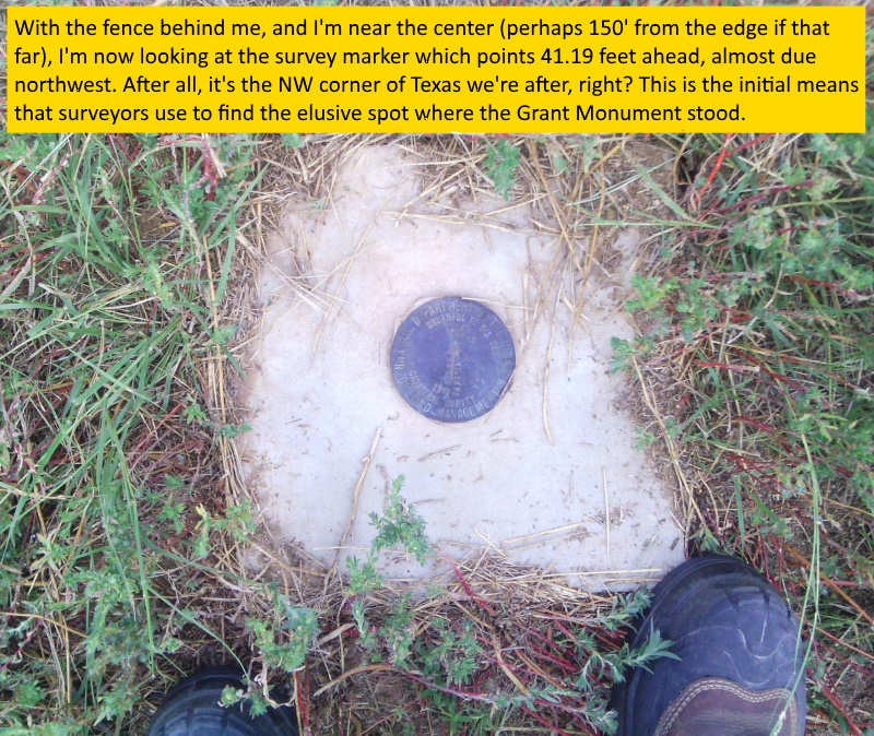
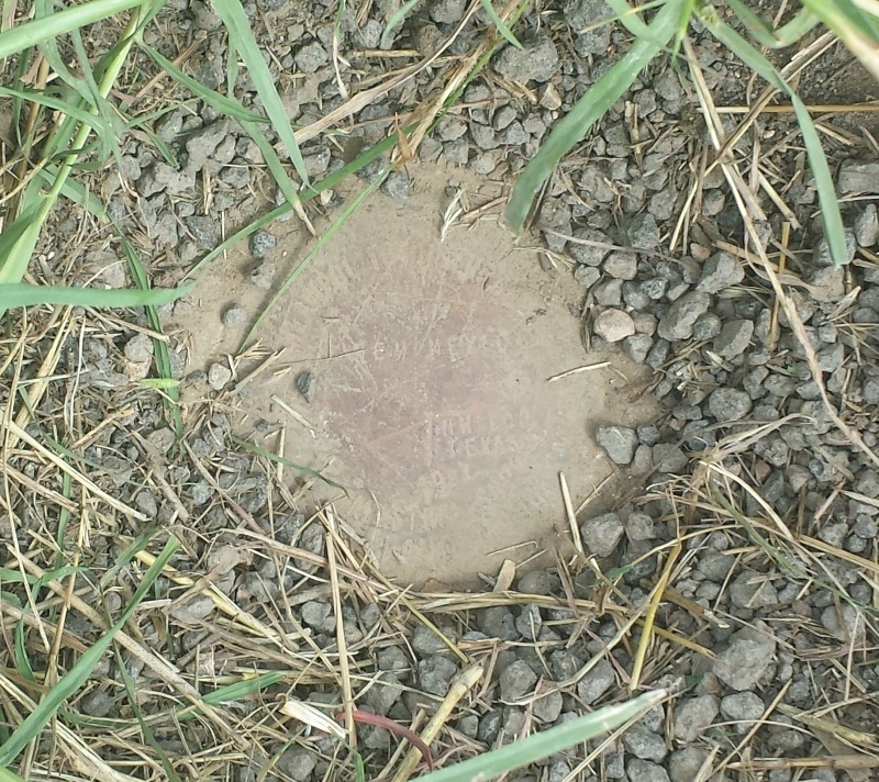
The first method most use is walking down the fence on the southeast side to find the initial survey marker. This trip is maybe 100' down at the most, but do watch for rattlers or other varmints. Due to nearby livestock operations, ticks are a possibility too. When you find it, it reads 41.19 feet from its center down the arrow, approximately northwest. Another thing you may find there or nearby is a geocache in a "bison tube", but I've not found it yet. You can carry a tape measure and have someone hold the tape edge while you walk down a set number of feet it will measure. Mark the spot with something you remove if you have to measure again from a point further forward to complete the 41 feet and nearly 3 inches. As you head forward, watch out for east bound traffic on your left! When you've reached the distance, if you're not directly over the marker, look closely to both your left and right. You should be within 3 feet of the highway shoulder's edge. The grass should give way in a spot to a worn, metal marker about 2 to 3 inches wide. Clear any debris from it and you should be able to read it. Congratulations, as you've reached the precise corner of Northwest Texas.
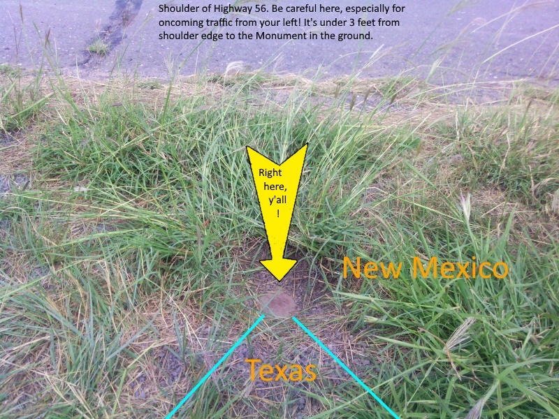
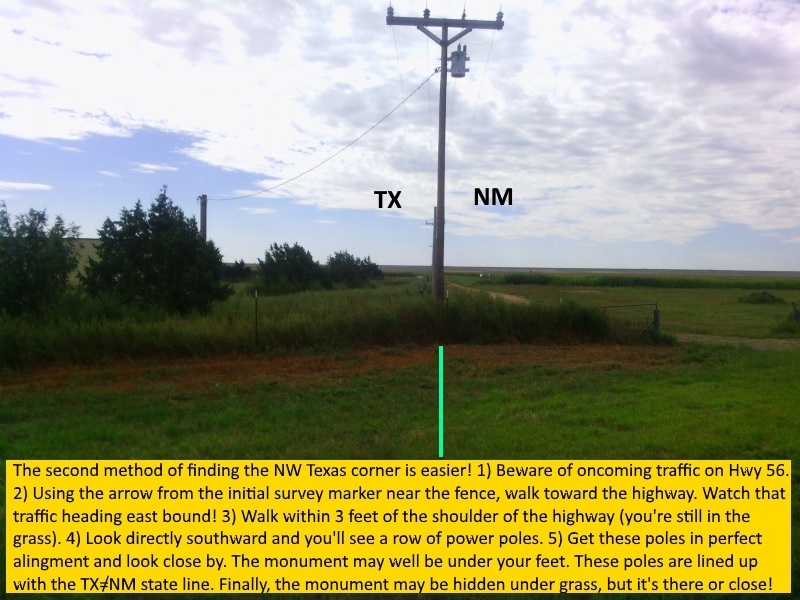
Now for the second and more simple method of reaching the marker. You don't even have to walk down the fence, but you still have to watch out for oncoming traffic on US 56, and they go at highway speed. The trick is quite simple as long as you can see some distance. Walk down just 3 feet along the highway edge and look about a 45 degree angle along your left (directly southward) for a series of power poles. As you see these poles come into alignment, be careful, as you may already be either on top of the marker which recesses slightly into the ground (I don't want you to slip and fall) or just inches away. When found, you'll notice how it lines perfectly with these poles, or better yet, the poles are half in Texas, the other half in New Mexico. The grass will barely give way for the metal marker, so clear it by hand and look for the NEW MEXICO, NW COR TEXAS markings. Congratulations, as you've reached the precise corner of Northwest Texas. Also, if you should drive down the road with the phone poles which perfectly lines up with the monument, there is barbed wire fence which in spots is reportedly from the XIT days. It's a simple 2-strand, 2-barb design they used back then.
Thanks to earthpoint.us for their coordinates converter! Note there are variances between their calculation versus what I grabbed with the GPS tablet.
Here's the information for the NW TX corner:
Position Type Lat Lon
---------------------------------------------------------------------
Degrees Lat Long 36.5004914�, -103.0416335�
Degrees Minutes 36�30.02948', -103�02.49801'
Degrees Min Sec 36�30'01.7689", -103�02'29.8804"
UTM 13S 675391mE 4041245mN
UTM centimeter 13S 675391.00mE 4041245.94mN
MGRS 13SFA7539141245
Grid North 1.2�
GARS 154LP49
Maidenhead DM86LM50AC08
GEOREF FJBG57503002
---------------------------------------------------------------------
Here's the information for the TX,OK,NM Tripoint, due east under 3 miles and just south of Rinker Road. Look for the Witness Post to easily locate it. Be prepared to walk over the cattle guard to the east, then make a 180 degree right turn and it's down a few feet, back towards the Witness Post.
Position Type Lat Lon
---------------------------------------------------------------------
Degrees Lat Long 36.5004398�, -103.0023796�
As Measured: 36.50043981 , -103.00237955
Degrees Minutes 36�30.02639', -103�00.14277'
Degrees Min Sec 36�30'01.5833", -103�00'08.5664"
UTM 13S 678907mE 4041312mN
UTM centimeter 13S 678907.10mE 4041312.45mN
MGRS 13SFA7890741312
Grid North 1.2�
GARS 154LP49
Maidenhead DM86LM90RC15
GEOREF FJBG59853002
---------------------------------------------------------------------
A final note if you're also after the tri-point down the state line road. There's the possibility the regular "straight ahead" road could be closed if the land owner is letting cattle graze, yet the road on the right, just past the Witness Post with the cattle guard is always open. You may choose to drive over the cattle guard. I usually park off the road, not crossing it, then carefully walk over the cattle guard. Watch out for rattlesnakes, although I've not come across any on my visits there. The monument is way over the weeds once you're past the cattle guard. Make a U-turn to the right on foot and walk westward. You'll come across the monument which is behind the witness post sign. New Mexico is on the NW corner, Oklahoma is on the NE side while Texas is clearly marked. The monument is sited way up in concrete so most can sit on it easily.